Chapter outline and page reference:
Introduction 173
Sieges of Uparkot 180
Adichadi Vav 181
Buddhist Cave Complex 183
Dhakka Bari 183
Entrance Gate 183
Guns 185
Jami Masjid 190
Kothar 192
Mahabat Khan Reservoir 193
Navghan Kuvo 195
Tomb of Nuri Shah 195
Chapter preview (first three pages only):
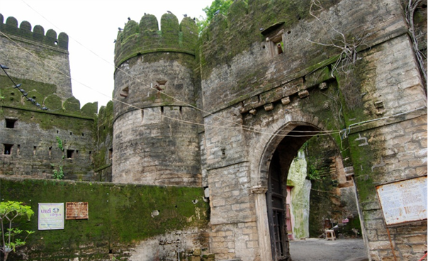
Figure . Entrance to Uparkot.
Introduction
Open 06.30–18.30, daily, closed every 2nd and 4th Saturday of the month. Entry free.
The Uparkot Fort, or Upper Fort, now a Notified Archaeological Site, on a plateau on the east side of the city, now practically deserted, was the citadel of the old Hindu princes, and is probably the spot from whence Junagadh derives its name. It is a rectangle approximately 650 m north-south, and 350 m east-west, 25 hectares in size, built upon a 30 m high elevation of limestone. This limestone was quarried in all directions in the eastern, or unoccupied part of the city, and is so soft as to be easily cut with a hatchet. It hardens however on exposure, and was invariably used as a building material.
In early 2007, when entry fees were cancelled, they were: Rs 2, vehicle entry Rs 25, two-wheeler entry Rs 5. Fees had been collected since 1991 and during this time a total of Rs 1,600,000 were collected, proceeds now planned to be utilised for the fort’s face-lift including permanent illumination of its historical monuments (Bukhari 2007e). Dalal Mott MacDonald (2003) reported that each year about 500,000 tourists visit Junagadh Fort. Uparkot is serviced by 22 guides who instruct tourists with information about the fort’s history.
In 1822 James Tod was the first European granted permission to enter the Uparkot, as he stated that ‘The influence of Mr. Williams obtained us ingress to the citadel, a favour never, it was said, granted before to any European’ (Tod 1839).
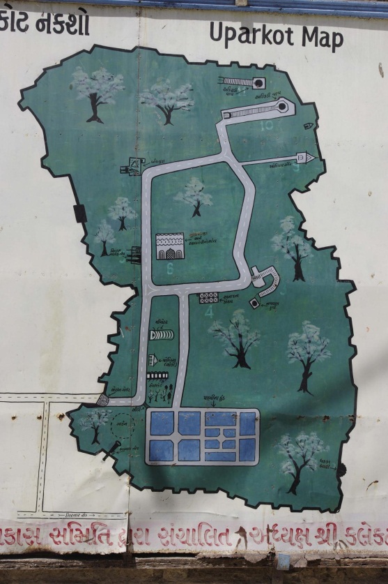
Figure . Map of Uparkot Fort, on a wall near the entrance gateway of Uparkot.
Regarding the antiquity of the fort, Tod (1839) mentioned that ‘If there could be a doubt as to the antiquity of the city, the appearance of the citadel would remove it. Every stone carries us back to days when…the fifth-six Yadu tribes had paramount sovereignty in India.’ Edwardes and Fraser (1907) suggested that this comment of Tod’s: ‘…means at least the second century in the Christian era.’ Thomas Postans (1838, page 874) described Uparkot as follows: ‘The old citadel is built upon an elevation of the limestone, which appears to cap over the granite at the base of the hills; and on which the city of Junagarh is situated…The Uparkot is a noble specimen of eastern fortification, its walls being unusually high, with immense bastions. The materials for these have been taken from a wide and deep ditch, which has been scarped all round it. There is only one gateway and narrow entrance from the westward…’.
Edwardes and Fraser (1907) said of Uparkot that: ‘…at one time it was not only a fortress, but packed within its walls were all the features of a town. In fact, the Uparkot seems to go back over immemorial centuries, for in excavations for the new reservoir layer after layer of houses and unmistakeable shops have been discovered built one upon top of the other…and it is unfortunate that they were allowed to be carried out without the supervision of a practical archaeologist.’ These authors added that: ‘…it is not necessary to assume that the present walls of the Uparkot represent the original structure. There were kings and warriors at Junagadh far longer ago than a thousand years, and it is reasonable to assume that the strategical advantages of the plateau on which the citadel stands must have impressed themselves upon the earliest founders of Junagadh. No doubt the walls that now exist were preceded by others’ and ‘…there is nothing to hinder the assumption that some sort of fortress may have existed there at least two thousand years ago.’
Marianne Postans (1839) had the following to say about Uparkot: ‘Erected upon a sandstone rock, at an elevation more considerable than the modern city, this fort is not only itself a picturesque object, but commands a magnificent view of Girnar, and the neighbouring country. The rock on which it stands, was originally excavated to form the walls, which are connected by substantial bastions, one of which is sixty feet in height. It is defended by a ditch, to the west and north; and is, on the whole, a very fine specimen of eastern fortification.’ The parapets on the east, where the place is commanded by higher ground, have been raised at least three times to give cover against the increasingly long range of projectiles.