Chapter preview (first three pages only):
At Girnar we have the unique record of an irrigation lake and dam which had been continuously maintained from Maurya Chandragupta’s time up to the very break-up of the Imperial Gupta Empire after Skandagupta, a period of nearly 800 years. An implied fact would be that Girnar, which was the provincial seat of Mauryan and Gupta Empires would have supported a flourishing town.
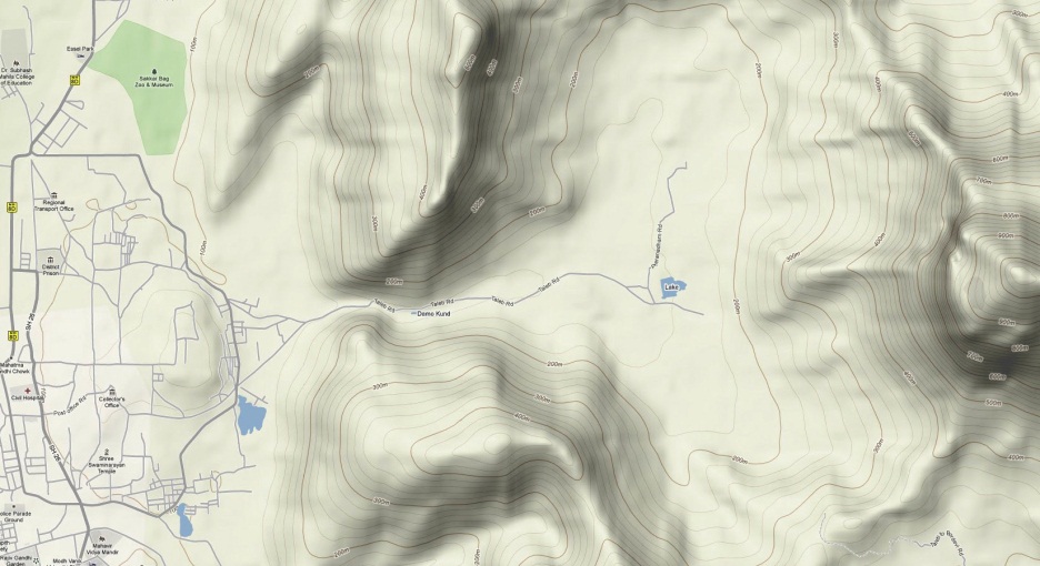
Figure 45. Relief map showing Junagadh City on the left (west), the Sonarekh Valley, Girnar Taleti, and the western edge of the Girnar central ridge on the right (from Google Maps 2010).
Da Cunha (1900, page 15) suggested that a symbolic representation of the Sudarshan Lake appeared on the reverse of Kshatrap coins from the time of Chashtana (early–mid 2nd century AD) till the dynasty succumbed to the Guptas at the end of the 4th century AD. On these coins there was a pyramid in the form of three arches having beneath it a wavy line, and Da Cunha’s explanation for this symbolism is: ‘that the pyramid of three arches or chaitya is the Girnar, the holy mountain, the wavy line representing the waters of the Sudarsana, the ancient sacred lake near Girnar.’
Before the location of the ancient Sudarshan Lake was established, Indraji and Buhler (1878) suggested that it might have been situated in Bhavnath Pass (Bhavanathun makun), the ravine leading east from Junagadh City into Bhavnath Valley and Girnar Taleti, and that he had found traces of the dam wall or embankment on the sides of the hills in the narrow opening of the valley a little above Damodar Kund and opposite the sanctuary of the Muslim fakir Jarasa. Watson (1884) also considered this as the probable site of the Sudarshan Lake: ‘Here the hills enclose like a circle a large basin, the only exit being the Suvarnrekha River. A bund 300 yards [274 m] long and fifty feet [15 m] high here would enclose a four-sided figure each side of which would be about one mile [1.6 km] long. It would amply repay the Junagad Darbar to bund up this pass into the hills, and again restore the lake, if only for irrigating the neighbouring country.’
Codrington (Jamsedjee and Codrington 1891) found Indraji’s suggested site to be untenable. His objections were that it did not suit the description of the lake in the Rudradaman Inscription ‘At the foot of the Girinagara or Junagadh Hill [i.e. Uparkot]’, it would have closed the way through the ravine to Girnar, it would have submerged Damodar Kund and other holy places, and in 1889 he did not detect the remains of the embankment to which Indraji and Buhler referred.
On the other hand, Watson (1884) considered the possibility that the lake may have been ‘in the enclosure of the hills to the north of the Girnar Mountain’. In fact, the present Hasnapur Dam, at 115 m, which provides water to supply the town of Junagadh, has been placed at this location. It has a dam wall (bund) about 380 m long, which retains a water area of about 0.4–0.5 miles2 (1.0–1.3 km2).
In a book by Sastri (1936), which includes the text, Roman transcript and English translation of the 3 inscriptions found on the Ashokan Edict Rock, the author said of the Sudarshan Lake that: ‘Its site, buried in deep jungle is now utterly forgotten and cannot be located with certainty.’ Atri (1967) made suggestions about the location of the lake, but Mehta (1968) summarily dismissed them as ‘…wild guesses on this subject without trying to identify old relics’. Goswami (1968) summarised what: ‘…we know about the history of the construction, devastation and repairing of the lake Sudarsana, which played a great part in the life of the people of Girinagara from circa fourth century B.C. to the fifth century A.D.’
Without archaeological evidence, Desai (1957) made an accurate suggestion that Sudarshan Lake ‘might have been at a place near the temple of Tripura Sundari Devi and Triveni Sangam, because at this place Palasini and Sonarekh joins.’ Chatterjee (1928) also made an accurate suggestion that the Sudarshan Lake was situated at the foot of ‘Joginia Hill’. Soundara Rajan (1985) made the pertinent comment that the Ashokan Edict Rock was situated ‘near the edge of what was once the Sudarsana lake.’
Khan Bahadur Ardeseer Jamsedjee, the Naib (deputy or assistant) Diwan of Junagadh, in the late 1880s was the first to successfully locate the site of the Sudarshan Lake (Jamsedjee and Codington 1891). He reported finding traces of two embankments of earth and stone-work which once crossed the Sonarekh River, and he supposed these to represent the remains of two separate dam walls, about 500 m apart, one the work of Chandragupta, and the other a later dam built by Rudradaman after the first had breached. He also found evidence of an embankment, which he called the ‘Vaghesri mound’ as it was near the city wall’s Vaghesvari Gate, which would have formed the southern shore of the lake, as well as a further embankment that he termed the Kalwa embankment, which ran north-south for about 1716 yards (1570 m) from near the Vaghesvari Gate to near the foot of Datar Hill, which was probably used to turn the overflow waters into the Kalwa water-course. Though wasted by time and quarrying, Jamsedjee found the remains of the embankments often remarkably massive and lofty. Not only this, but he reported following on foot the whole circuit of the lake, as well as discovering the sluices or conduits which the Rudradaman Inscription mentions. Jamsedjee estimated the size of the first and second Sudarshan Lakes: ‘When the dam burst at this spot, in searching for a fresh site, the engineers naturally chose one further down the river, as, if successful, it would so greatly add to the size of the lake. So far as we could roughly estimate the first lake when full would cover 140 acres (57 ha = 0.57 km2) and the second about 138 more or 278 acres (113 ha = 1.13 km2) in all.’
Of the Sudarshan Dam conduits and sluices Jamsedjee had the following to comment (Jamsedjee and Codington 1891): ‘I would offer the following explanation of the references to conduits in the Rudradaman inscription. The original or Chandragupta river-bed dam was solid with no openings or conduits. The embellishment with conduits by Tushaspa Asoka’s Viceroy was the dangerous device of opening sluices in the main river-bed dam to scour silt and draw off floods. This is proved by the remark in the Rudradaman inscription that when the river bed dam was breached the structure of Tushaspa’s conduits was visible in the breach. In the A. D. 129 flood the stones, bushes, trees and tangled creepers swept down by the flood and hurricane
Found your article very interesting and wish to explore more. Could you kindly send me the full unabridged version of Chapter on Sudarshan Lake?I have been trying to locate the English translation of the Girnar Rock edicts without success, perhaps you could send me those as well?
Warm regards,
Vijay Paranjpye
Hi Vijay
I’ve emailed what you requested. I hope you keep in touch.
Cheers
J.