
Figure 1. Map of the Girnar Hills (from 1:250,000 map: Porbandar NF 42-11), with superimposed relief of Girnar from Google Maps.
When describing Kathiawar or Saurashtra, Balfour (1885, page 520) remarked that: ‘The highlands are remarkable for isolated mountains, amongst which is Girnar, rising to 3500 feet almost perpendicularly. It occupies the middle of a circular basin, into which admission is gained by four passes at the cardinal points of the compass.’ Describing the Girnar Hills, Roy (1968) wrote that: ‘These hills occupy roughly a circular area. The central portion is ridge like and contains the highest peaks. It runs east-west and splits up into two branches at each extremity. Surrounding the central ridge there are four arcuate ridges each on north-east, north-west, south-west and south east portions forming more or less a perepheral [sic] ring.’
The ground of the Girnar Compound is extremely hilly and rugged with moderate to very steep slopes which frequently pass into precipitous inclines, the higher portions of the centrally situated Mount Girnar becoming at places a sheer perpendicular wall. There is very little flat or undulating land in the Girnar Forests. The magnificent mass rises in the centre to a maximum height of 1,117.4 meters, the highest point in the Saurashtra and Kutch regions of Gujarat. Along the east-west length of the central ridge lie the famous peaks of Ambaji, Gorakhnath, Oghadnath, Dattatrey, Gabbar or Anasuya, and Kalika. Most slopes of this mount are precipitous and rocky, supporting little tree growth. It is girt by almost an unbroken series of smaller hills lying within a radius of 4 km from its central peak of Gorakhnath.
Marianne Postans (1839), who visited Girnar in May 1838, described it as follows: ‘The summit, a bare scarp rock, becomes richly wooded towards the base, blending with a deep ravine, clothed with forest-trees, and intersected by rivers, swollen by the mountain torrents. From either side of the Girnar, spurs strike out into a lower range of hills, their ridges fringed with the feathery beauty of the bamboo, and their sides clothed with various jungle-plants; from which shelter, huge blocks of granite jut out, in the most rugged and fantastic forms.’
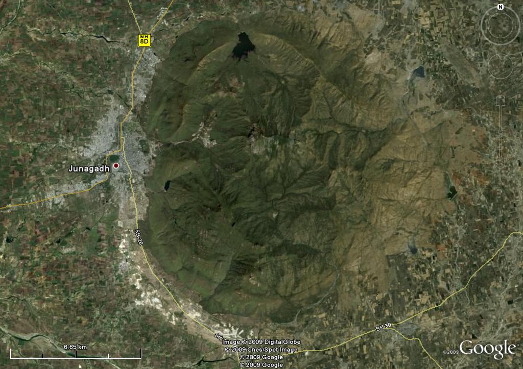
Figure 2. Satellite image of Mount Girnar and Junagadh (from Google Earth).
Fedden (1884) described the Girnar Hills as follows: ‘The Girnar, or Junagarh, group is the most important and interesting, from its singular and imposing form and proportions. The topographical features of this group have often been described, – the great central mass called the Girnar, over 3,500 feet in height; and the outer annular ridges, steeply scarped on the inner side, but sloping away at varying inclinations outwardly.
‘The Girnar mountain is a majestic pile of diorite rock, with terrific scarps and precipices, propped by diverging buttresses, which, inosculating with the surrounding ridges, give rise to four distinct areas of drainage, each discharging through one of the four gorges in the outer ranges. This central pile, which is far loftier than the surrounding ridges (save that to the south, whose highest point [Datar Hill at 2779 ft.] nearly rivals it), assumes somewhat the form of a huge cupola, laterally compressed, and is crowned by several sharply defined peaks of an extremely precipitous and picturesque character; the loftiest attains a height of 3,666 feet above sea-level….The crest of the mountain and some of the peaks are adorned with many Buddhistic and Jain temples of richly carved stone.’