Chapter outline and page reference:
Introduction 23
Age of Girnar 25
Girnar as an Eruptive Volcano Core 28
Girnar as a Plutonic Intrusion 32
Rock Types and Minerals at Girnar 40
Palaeomagnetism at Girnar 51
Miliolite Limestone at Girnar 52
Soils of Girnar 56
Osam Hill – Geology 57
Osam Hill – Some Miscellaneous Notes 65
Chapter preview (first three pages only):
Introduction
Sukheswala (1982) briefly described the history of the study of geology of Girnar: ‘A major igneous complex in the monotonous Deccan Trap terrain, Mount Girnar (over 3500 feet high) has, from very early times, attracted the attention of geologists. Amongst the earliest workers were Fedden (1884) and Evans (1901). The former gave a good idea of the geology of the area, while the latter made a representative collection of the various rock types, which were later investigated petrographically by Krishnan (1926) [1925]. The first concise and systematic geologic account of the rock types and a discussion of their genetic relationships were given by Mathur et al. (1926). Attempts to study the genesis of these rocks were made by Subba Rao (1964), Bose (1965, 1971, 1973), Wakhaloo (1967) and Paul et al. (1977).’ Chatterjee’s (1970) account of the history of the study of Girnar’s geology follows: ‘The structure, petrology and age of this complex has been very controversial. Mt. Girnar was considered by Fedden (1884) as a volcanic plug made of a majestic pile of dioritic rocks. The outer slopes of Mt. Girnar are occupied by the basalt flows of Deccan Trap age. Evans (1901) described monchiquites from Mt. Girnar, and was not sure whether they were of Deccan Trap age. Mathur, Dubey and Sharma (1926) considered Girnar complex as a laccolithic intrusion into a thick covering of Deccan Traps, hence apparently younger than Deccan Traps. Wakhaloo (1967) argued that Mt. Girnar is not of the nature of the core of a central type of volcano, while Subba Rao (1964) maintained that it is a central type.’
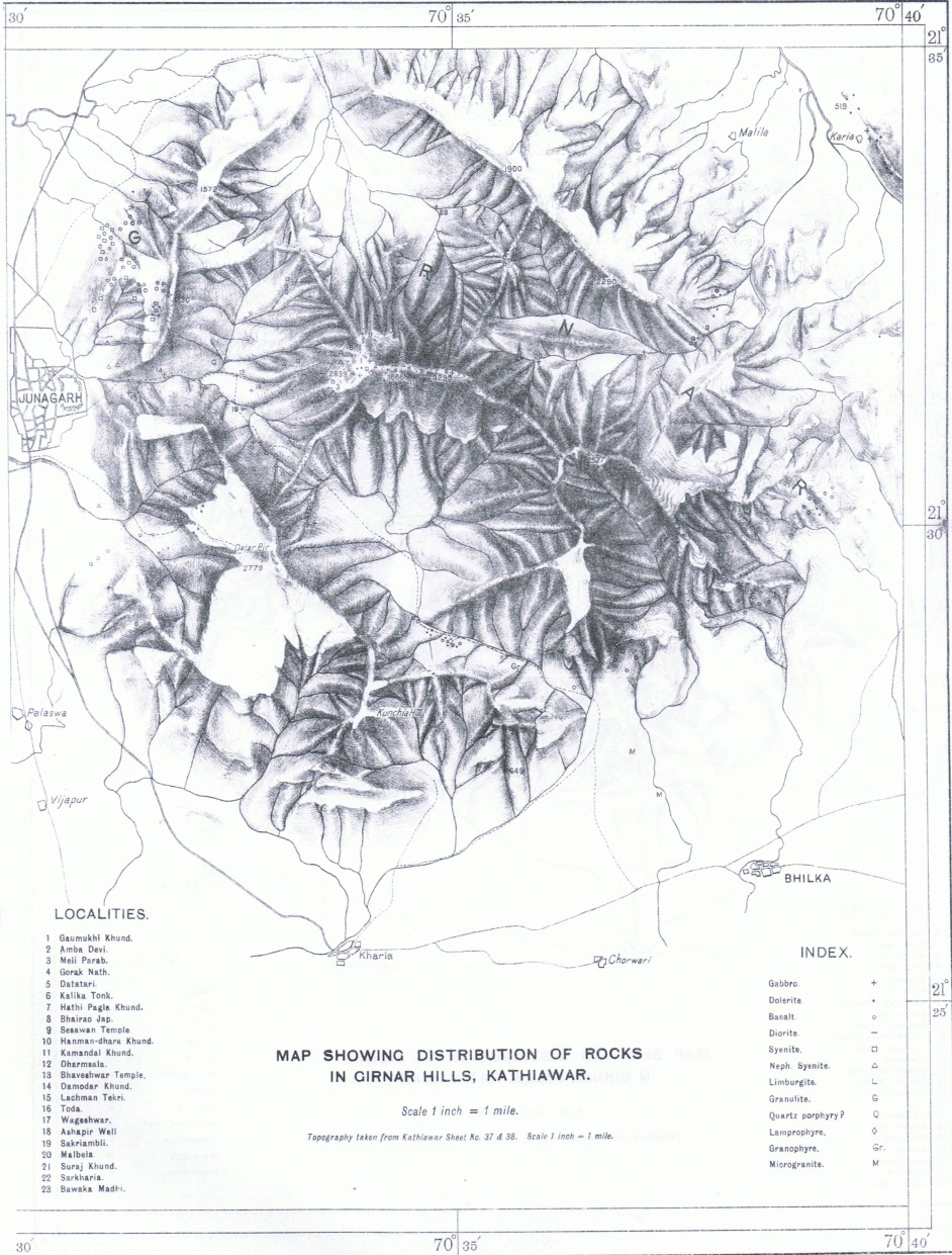
Figure 4. Map showing distribution of rocks in Girnar Hills (from Krishnan 1925, who utilised 1: 63,360 map sheets).
A list of references to the geology of Girnar Hills, and Osam Hill, is presented in Appendix 3.
Age of Girnar
The Mount Girnar Complex (21º26′ – 21º35’N; 70º28′ – 70º40’E) is the largest intrusion in the Kathiawar uplift in Gujarat State and is considered to be related to the Narmada–Son rift. Chandra (1995) suggested that: ‘The GLC [Girnar Layered Complex] represents one of the several eruptive centres in the alkaline subprovince within the Deccan Traps…It is the fourth and last in a chain of eruptive centres associated with the Narmada-Son lineament considered by most workers to be a rift zone…’. In reference to the mantle convection pattern under India, Crawford (1983a) pointed out that: ‘Girnar appears to be a node, lying as it does where the prolongation of the Narmada-Son zone meets that of the Aravalli trend…Girnar lies precisely at a point of upwelling mantle flow. The Lonar and Girnar points are the only two in India…It may be pointed out that the Girnar complex has an age of about 50 Ma and that the mantle flow pattern then may have been different from that of today. But if the correspondence is coincidental, then it is also very remarkable’ (see also Crawford 1983b).
It has been designated the Girnar Layered Complex (Karkare and Chandra 1988), Girnar Igneous Complex, Girnar Magmatic Complex, Girnar Layered Series, and Girnar Ijolitic Series (Chandra 1995), and placed between 60 and 58 ± 2 million years old (Chandra 1995). The Girnar Layered Series is the plutonic counterpart of the Girnar Ijolitic Series which includes the intrusive dykes constituting several rock types. The complex comprises a series of layered gabbros and syenites (Chandra 1995). Diorites from the Girnar Hill have been reported to be 66–67 million years old (Kaneoka 1980). The age of a rock sample of diorite from Girnar determined by Kaneoka and Haramura (1973), of 65.3 ± 1.3 m.y., was almost the same as the age of rocks from Girnar obtained by Wellman and McElhinny (1970) (65 ± 1 m.y.). Paul et al (1977) stated that: ‘New K-Ar age determinations show a range from 63.8 to 56.2 m.y. and suggest that the igneous complex was emplaced immediately after the eruption of the Deccan basalts.’
According to Subba Rao (1972): ‘An examination of the field setting of the rocks which are exposed clearly,…would not leave any doubt with regard to the age of the intrusion as the post-eruptive phase of the Deccan Trap igneous activity.’ He also reported that ‘…the radiometric age determinations obtained by Prof. W.D. West…for the nepheline syenite of the Girnar, stand in conformity with the age of the Deccan Trap period for the rock’. Although this is the broadly accepted age of Mount Girnar, Chatterjee (1970) ‘argued that Mt. Girnar is of Archaean, probably Mundwara age, and not of post-Deccan Trap age as suggested by various workers’. He proposed that the rocks of Mount Girnar ‘suggest that we are dealing here with rocks older than the Deccan Traps’ and that ‘Mount Girnar is a pre-Deccan Trap age intrusion and is probably of the same age as the Mundwara ring complex’. The Archaean Eon lasted from 4,000–2,500 million years ago. Chatterjee (1960, 1970) believed that the Mundwara Igneous Complex also belonged to the Precambrian (> 500 million years), but most workers assign it, like Girnar, to which its rocks bear striking resemblance, to the Deccan Trap period (e.g. Subba Rao 1972), and Basu et al (1993) dated it to about 68.5 million years old.
Murali (1974, page 255) commented on the oceanic origin of the basalts of Girnar: ‘Both from major element and trace element abundances, and from the element ratios, these basalts are found to be nearer to oceanic island basalts and are broadly different from continental basalts in general. The magnitude of concentration of elements K, Rb, Cs, REE, Th, U and Pb and Rb/Sr ratios and Sr isotopic data etc., supports the oceanic ridge association of Mount Girnar, which is consistent with seismic studies and magnetic anomaly patterns…’.
Some authors suggest that, as a consequence of continental drift, India collided with Asia between 55 and 50 million years ago, whereas others maintain that it was much later at around 35 million years ago. This northward movement of India gave rise to the uplift of the Himalayan Ranges. As Girnar is assigned approximately to the Deccan Trap period, i.e. about 65 million years ago, it is therefore very much older than the Himalayas! The Girnar igneous laccolithic plutonic intrusion formed when the Indian tectonic plate was moving over a hotspot in the Indian Ocean, caused by a mantle plume. If it can be assumed that the plate is moving north at about 5 cm per year, then Girnar may have formed when it was about 3,250 km south of where it sits today, somewhere near where the island of Diego Garcia is now located.
Pascoe (1964, page 1395) considered that Girnar: ‘…Mountain originally must have possessed vast proportions compared with its present denuded remnant’.
SIR,
PL. CONFORM THE AGE OF GIRNAR,
AS I HAVE HEARD THAT IT’S AGE IS 22500 M.Y.
Hi Hemant
In response to your comment, I have inserted a few more sentences at the end of the last paragraph of this post. I mentioned Chatterjee’s suggestion that Girnar was of Archaean age. There are many geologists who have given this issue of Girnar’s age much consideration, and the overwhelming weight of evidence suggests that it came into existence sometime near the Deccan Trap period. If you are interested in reading any of the geological papers about Girnar, I would be more than happy to provide them.
All the best
John
The Map showing the distribution of rocks in Girnar Hills is very much informative & illustrative also.
I will be obliged if you could provide another Map by showing the existing Route with ‘Steps’ to Girnar Temple(s) from Base Point – superimposed on the above Reference Map, Sir.
I will be visiting Girnar Temple(s) in coming September, and the Map I sincerely request will enable me to understand Girnar Geology much better.
Regards,
Chandrakant Kulkarni, Pune (India)
Hi Chandrakant
All of my 33 chapters on Girnar and Junagadh are now published on Amazon Kindle Books. In chapter 28, on geology and geomorphology, I have included a number of maps. My blog website has a small snippet from this chapter.
I don’t know your particular interest in Girnar, but if it is geology, then chapters 27 on Girnar topography, and 29 on geographic features, include related information. If you are interested in Girnar’s temples then I would recommend chapter 20 on important sites at Girnar, which also has maps. On my blog I have extracted from chapter 20 some information about the various Girnar stairways: http://junagadhgirnar.com/stairs-at-girnar/
By the way, if you intend to climb to Gorakhnath and Dattatreya peaks, I have given some information about these in chapter 29. And if the Jain temples at Devkot on route to Amba Mataji are of interest to you then these are treated in chapters 23 and 24. If you have time available, and would like to explore Girnar more widely than just the central peaks, then chapter 20 covers of broad range of somewhat lesser-frequented temples.
Exploring Google Earth of Mount Girnar can be very enjoyable, and instructive to get a good feel of the lay of the land.
If you have any queries I would be happy to try my best.
I hope your trip to Girnar in September is enjoyable.
All the best.
John
Jay girnar Jay naminath
Yes, well said Pashva.
Jai Girnar. Jai Neminath.