Chapter outline and page reference:
Introduction 70
Ado Dungar Hill 71
Allichhipra 72
Ambaji Peak 72
Anasuya Peak 72
Aswatthama Hill 73
Bhavnath Valley 73
Bhensla Hill 75
Bordevi Valley 75
Boria Choki 77
Boria Ghodi 77
Chorghori Ridge 77
Chorpani Hill 78
Datar Hill 78
Dattatrey Peak 87
Dhrubakio Hill 93
Dungarpur Valley 93
Gadhekot Peak 93
Ganadevi Nala 94
Gorakhnath Peak 94
Gudajali River 98
Ghodmukha 98
Ghurmukha 98
Hajam Hill 99
Hasnapur Valley 99
Jogania Hill 100
Kabro Hill 100
Kalagadba Valley 101
Kalichhipra 101
Kali Dhar Ridge 101
Kalika Peak 102
Kalwa River 106
Kanaiyo Hill 106
Khodiyar Hill 107
Khorial Ridge 107
Koribara Ridge 107
Kunchia Hill 107
Lakha Medi and the Boria Stupa 107
Lambdhar Hill 107
Lhasa Pawan Ridge 108
Lol River 109
Makhan Kundi Hill 109
Malvela Ni Ghodi 109
Mathura Valley 110
Matri 110
Oghad Peak 110
Ojat River 111
Palasini River 112
Pavandhoda Hill 112
Peetlion Ka Pani Ridge 113
Ramnath Valley 113
Ranamerno-Pano Hill 113
Renuka Peak 113
Sajariali Ridge 114
Sonarekh River (on the Western Side of Girnar) 115
Sonarekh River (on the Eastern Side of Girnar) 118
Suraj Kund Valley 118
Taktakgiyo Hill 118
Tali Dungar 118
Utavali River 118
Chapter preview (first three pages only):
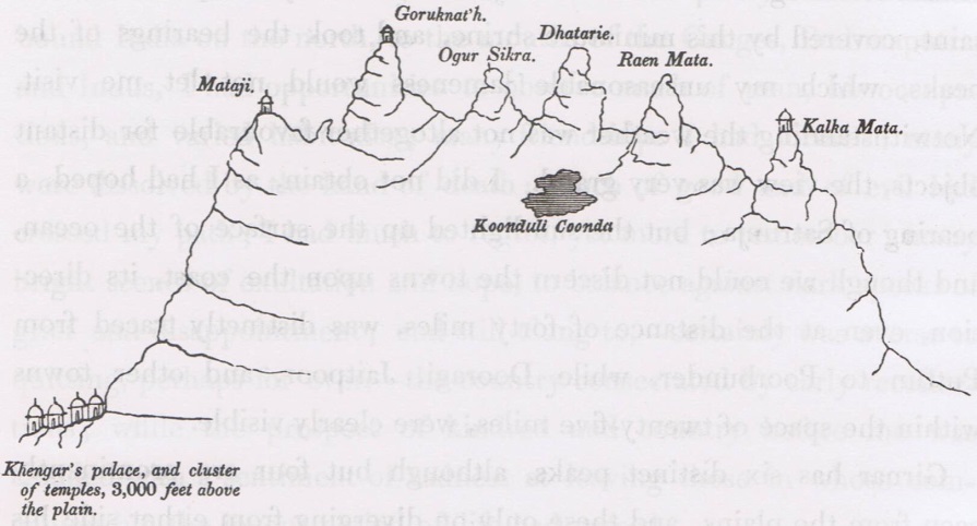
Figure 19. Sketch map of the cental ridge of peaks at Girnar, looking northward (from Tod 1839).
Introduction
When referring to ‘the [mountain] called Gomanta’ the Harivamsa mentions that ‘its two highest horns have the form of two shining gods’. This could well be a reference to the conspicuous twin summits at the very centre of Mount Girnar, i.e. Oghad and Dattatrey Peaks. These twin peaks might also be seen as Balarama and Krishna (or as Nara and Narayana), as the Harivamsa reports that these two brothers leaped off the mountain compressing it with their footprints in the process (Harivamsa 2.42.81–82): ‘After Rama (Balarama) jumped down, Krsna, similar to a black rain cloud, highly valiant, jumped down from the peak of Gomanta. Then Hari (Krsna) pressed down the best among mountains (girivara) with his foot. The mountain, pressed thus, was compressed all around.’
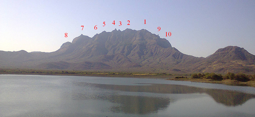
Figure . Photo of the cental ridge of peaks at Girnar, as seen from the north, at Hasnapur Dam. 1 – Amba Peak; 2 – Gorakhnath Peak; 3 – Oghad Peak; 4 – Datta Peak; 5 – Anasuya Peak; 6 – Renuka Peak; 7 – Kalika Peak; 8 – Ghurmukha Peak; 9 – Bhairav Jap; 10 – Dev-kot.
Some Jains identify Gorakhnath, the highest peak of Girnar and the second peak from the west (Ambika being the first), with Neminath, as well as with Krishna’s grandson, Aniruddha, the next peak (Oghad) with his son (Samba), and the fourth (Dattatrey Peak) with another son (Pradyumna). A variation of this theme could see the third peak (Oghad) associated with Balarama, Krishna’s brother, and the fourth peak (Dattatrey) associated with Krishna himself. On the other hand it is popular Jain understanding that Dattatrey Peak is specially associated with Neminath.
Ado Dungar Hill
Ado Dungar Hill (579.1 m) is in the north of the Girnar Compound (Rajyagor 1975). It is part of the Ado Ridge, and is north-east of Nes (mentioned in Mathur et al 1926). The Ado Ridge is part of the outer rim of the Girnar Compound, extends for about 4.5 km, and runs with a north-west to south-east orientation. Its north-west end is just east of Hasnapur Dam, and its south-east end meets the Peetlion Ka Pani Ridge. It is about 580 m ih height near its south-east end and about 365 m high toward its north-west end (mapped in Mathur et al 1926, Chandra 1995). Chatterjee (1928) mentioned that ‘Addo’ Peak has a height of 1,200 feet (366 m).
Allichhipra
Allichhipra, also called Chippar, is in the north of the Girnar Compound, west of Jina Bava’s Madhi (mapped in Chandra 1995). It is part of the north-west radial ridge, extending from the central Girnar Ridge to the peripheral circle of hills, and is approximately midway between Girnar Taleti to the south and Hasnapur Dam to the north, which are about 4.5 km apart. It is a large, exposed, unvegetated area of relatively smooth and gently sloping rock, about 200 m north-south and about 100 m east-west, ranging in altitude from 280 m at its southern edge to 350 m towards the north.
Desai (1954b) referred to Allichhipra
TRAVELLERS OF LILI PAREEKRAMA..MORE THAN 12. LACS. EVERY YEARS STILL ARE UNKNOWN TO THIS FACTS AND ALSO OLD NAME GOMANTAK HILLS. THE ROUTE OF LILI PREEKRAMA WITH NAME SHOULD BE GIVEN TO PLACE .WILL FULFILL THE DEMANDS OF NEW GENERATIONS WITH ITS IMPORTANCE..
Hi Pravin, thanks for your comment.
I agree with you, that most people don’t yet know many of the details about the incredible Mount Girnar. For instance, you mentioned its old name of Gomantak. I have prepared some notes about this name, along with many of the other early names for Mount Girnar.
My aim is tell the world about the exceptional significance of Girnar.
You also mentioned the Lili Parikrama. I have prepared some notes about this event, and I will give them here, if you are interested in having a look. The notes come from my chapter 21, on Girnar Festivals. I have deleted the maps of Girnar, with the parikrama route, but if you would like to see them just let me know, and I can insert images later. And of course, I have also left out all of the references in full.
Girnar Lili Parikrama
The annual Girnar Lili Parikrama (pradakshina or circumambulation) takes place from Kartik Sud (bright half) 11 to 15 (around mid November). The festival is held with the awakening of the gods (Dev Prabodini Ekadasi = awakening 11th, i.e. the end of Chaturmas), when religious minded people have completed their course of penance and religious observances, and the public at large is ready for the festival of Dev Divali, or Divali of the gods. It is believed that a night of the gods lasts for four months (chaturmas), and that they wake from their prolonged slumber each year on the first ekadashi of Kartik, which is celebrated as Dev Divali. It occurs when people are free from agricultural pursuits, and when Girnar is covered with green vegetation after the plentiful rains of the monsoon. It is believed that those who complete the parikrama will, after death, attain Moksha (Lal 2000a). From the social viewpoint the festival has considerable significance as people of varied communities get together for a common cause. The festival ends after four days, on Kartik Purnima, the full moon day of the month of Kartik, which in Gujarat marks the new year, that falls on Divali.
According to Mate (1991–92): ‘…the ‘Girnar Parikrama’ attracts thousands of devotees mostly villagers and tribals from Saurashtra…They are following in the footsteps of their forefathers who must have been doing the same since times immemorial. Thus, this gathering, fair, would go back to pre-Buddhist times, proto- perhaps pre-historic times. It is a folk cult or festival. These people, when gathered together, must have indulged in singing, dancing, perhaps drinking and merry-making in general.’ It is believed that after winning the Mahabharata war at Kuruksetra, the Pandavas did the Girnar parikrama to seek God’s blessing. Subhadra, the sister of Krishna, circumambulated and worshipped Raivataka Mountain, and it was during a festival worship of the mountain itself that she was abducted by Arjun (White 2003).
It is believed by some that sadhus of the Nath Sampradaya first made the parikrama of Girnar, going around the seat of the gurus of their sect, particularly Dattatreya and Gorakhnath (Bezbaruah et al 2003). On the other hand, Lahiri (2011) suggested that the early pilgrimage circuit of Girnar may have been a Buddhist one: ‘Of great interest, though, is the distribution of the other sites in the Girnar forest area which begins to make sense when it is juxtaposed with the topography of the hill zone. The Girnar forested tract does not have a great deal of flat land. There are only four small valleys between the Girnar range and the surrounding hills. These are in the vicinity of Bhavnath, Hasnapur, Surajkund and Bhordevi. It is, therefore, not surprising that the famous Girnar ‘parikrama’ which starts annually from November onwards, begins at Bhavnath, passing through the forest via Intawa ni Ghodi, to reach Jina Baba ki Madi, and then across Madvela to reach Bhordevi from where pilgrims move back to Bhavnath. The traditional halting places in the pilgrimage circuit, in fact, are Bhavnath, Jina Baba ki Madi, Surajkund and at Bhordevi.
‘It is in the vicinity of these very places that early historic brick ruins are found. Intawa, for instance, is above Bhavnath and is a Buddhist monastic site. Suraj Kund is marked by a late centuries BCE well and other undetermined brick remains which may well be part of a Buddhist ruin. As for Jina Baba Ki Madi and Bhordevi, both are marked by remnants of Buddhist stupas. Thus, much before its fame as a centre of Jain and Hindu worship, Girnar appears to have been sacred to the Buddhists and possibly, the earliest circuit of worship in and around the great Girnar was a Buddhist one.’
The 30 km, four-day walk through the forest, around the central prominence of Mount Girnar, attracts more than one million people. Trivedi (1964, page 243) indicated that in 1961 the estimated number of participants was 100,000. It was reported in 1997 that ‘five or seven lakh people assemble there’ (Lok Sabha 1997, page 18), and in 2003, 1.2 million people participated in the event (Bukhari 2008a, b). Lal (2000a) estimated that more than 1.6 million people visit the forest/ hills of Girnar annually to offer their prayers to various deities. The parikrama is organised by the Junagadh District Collectorate, police, government departments which manage forests, health, and water, as well as voluntary organisations. The Forest Department maintains the walking path, the health department arranges medical camps en route, and voluntary organisations provide food and water at regular intervals. In 2008 about 70 annashetras (free food facilities) were opened along the parikrama route. In 2009 there were about 100 such community kitchens which provided free food for pilgrims (Yusuf 2009).
In recent years the Forest Department banned plastic bags and gutka (a chewing stimulant of betel nut, tobacco, catechu, lime and flavourings), firecrackers, lighting fires, loudspeakers, radios and private vehicles (Bukhari 2007c). In 2005 more than 2 tonnes of plastic waste was collected and destroyed by volunteers; and there is concern that there will be damage to the forest and hazard to wildlife (Bukhari 2006a). In 2011 volunteers cleared close to six tonnes of plastic from the sanctuary after the parikrama. The volume of plastic was expected to be much more in 2012, as the very dry conditions caused the authorities to informally permit private water pouch sellers to set up stalls on the route. The 30 water supply points on the route were not sufficient to meet the needs of the 800,000 pilgrims (Parmar 2012). Under the Wildlife Protection Act, unauthorised people are not permitted to remain in the Girnar Wildlife Sanctuary after 6 pm, except during the annual Girnar Lili Parikrama Festival. A group of visitors who stayed at Bordevi in June 2012 received a substantial fine for this offence (Kaushik 2012).
The parikrama route stages are (Travel Blog 2008):
Kartik Sud 12 — Bhavnath to Jina Bava’s Madhi (9.1 km),
Kartik Sud 13 — Jina Bava’s Madhi to Malvela (3.2 or 8.2 km),
Kartik Sud 14 — Malvela to Bordevi (5.2 km),
Kartik Sud 15 — Bordevi to Bhavnath (7.7 km).
Before the parikrama many pilgrims choose to bathe in the sacred waters of Damodar Kund, Revati Kund and Mrugi Kund, after which they have darshan of Damodarji, Muchkund, Brahmeshwar, Dudheshwar and Bhavnath Mahadev (Bezbaruah et al 2003).
The parikrama starts from Dudheshwar Temple and plantation, at Bhavnath Taleti (155 m altitude), and passes over the Intwa Ni Ghodi (Intwa Pass) of the Koribara Ridge, at an altitude of about 280 m, before reaching Jina Bava’s Madhi (also known as Raniyo Kuvo), 2.5 km south-east of Hasnapur Dam. Many pilgrims start this walk early, at about 3 to 4 am, and reach Jina Bava’s Madhi (180 m altitude) by sunrise, where they encamp for the whole day. Late in the evening and at night, there are programmes of bhavais, Ramlila or Krishnalila (plays depicting the life of Ram or Krishna), ramadhuns and bhajan-kirtans (singing of devotional songs), and kathavrata (hearing of stories from the Bhagavata, Ramayana and Mahabharata). The Chandramuleshwar Mahadev Temple is located near here, but one needs permission from the Department of Forests to access this temple site.
After a night halt the route provides two options, one can proceed directly to Malvela, where there is a beautiful temple, or alternatively reach it via Sarkhadiya Hanuman, a Hanuman Temple in dense forest. The direct route to Malvela heads south, following a creek bed, before crossing a pass (510 m altitude) after about 2.1 km, and then proceeds to Malvela (320 m), about 3.2 km from Jina Bava’s Madhi. The alternative route heads east from Jina Bava’s Mahdi, along a creek line and up to a pass (470 m altitude) after about 1.9 km. The track over the pass takes one down to Sarkhadiya Hanuman Temple (270 m altitude), about 3.8 km from Jina Bava’s Madhi, and then on to Suraj Kund (225 m altitude) after another 1.9 km. Pilgrims can bathe in Suraj Kund. The distance from Suraj Kund, west to Malvela, is about 2.5 km.
Pilgrims generally leave very early so as to arrive at Malvela by sunrise. Bezbaruah et al (2003) reported that: ‘the footway from Madhi to Malvela is so narrow in the beginning that pilgrims have to walk in a line. The spectacle of thousands of people queueing up the wooded mount is a sight worth seeing. Then follows a dangerous and difficult steep path up and down a tall hill. At a certain stage, one has to tread one’s way carefully and cautiously to avoid falling into a deep valleys below.’
The next day’s stage, to Bordevi Temple, takes one south, over Nal-Pani Ghodi (or Malvela Ni Ghodi), a steep and tough pass at 475 m altitude. At the top of this ghodi there is a forest hut where pilgrim numbers are counted. The distance from Malvela up to the pass is 1.1 km, and to Bordevi is 5.2 km. At Bordevi (260 m altitude) there are places which carry water all year round, such as Kaala Ghuno and Tataniyo Ghuno. Tataniyo Ghuno (or Khodiyar Ghuno) gives shelter to crocodiles. It is said that lucky people may here see a crocodile with a golden earing.
The following day’s walk takes one back to Bhavnath Taleti, along a ‘pucca’ and motorable road, a distance of about 7.7 km.
The total distance of the Lili Parikrama is 25.2 km, proceeding from Jina Bava’s Madhi direct to Malvela, or 30.4 km taking the detour to Sarkhadiya Hanuman Temple and Suraj Kund.
The Forest Department’s proposal to convert the reserved Girnar Forest into a sanctuary, which was sanctioned by the Gujarat State Government, was opposed by local sadhus and temple heads. There were fears that devotees and pilgrims would have to seek legal permission to enter the area, and that night halts would be prohibited, which would mean that the centuries-old tradition of parikrama would come to an end. The opposition was led by the All India Sadhu Samaj (Gujarat Chapter) president and head of the Girnar Sadhu Mandal, Mahant Gopalanand (Bukhari 2008c). Nevertheless the Girnar Forest was declared as a Wildlife Sanctuary by the notification of Government on the 31st May 2008, and the Girnar Lili Parikrama continues unabated.
An extended Big Parikrama, encircling the entire Girnar Compound, was once conducted, which took a total of seven days. The clockwise journey started at Bhavnath, with night stops at the settlements of Bamangam (13 km), Baliyawad (7 km), Kharchiya (9 km), Chhodawadi (7 km), Bilkha (12 km), and Khadiya (9 km), returning to Bhavnath (17 km) on the seventh day.
See Anonymous (1999) and Doshi (2007) for Gujarati accounts of the Girnar Parikrama.
Interesting.
Pravinbhai,
John has narrated a long detailed reply to your small question. Only John would do it. Anil